
It’s a gem!
“In the beginning God created everything, including a strip of beach rising along the south shore of – what the indigenous peoples called: ‘Ontari’io’ – ‘Lake of Shining Waters’ – and God saw that it was good!“
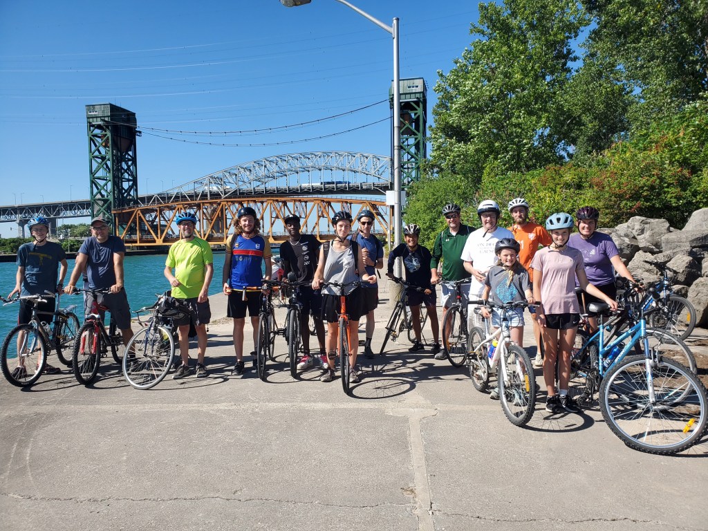
Last Fall 2024 concluded another summer that I was able to bike the Burlington/Hamilton Beach Trail on my e-bike. What a treasure this has become for me. An awesome ‘creation’ gift for all local residents.
This setting of nature, beach and water are an unending delight to the senses for the enjoyment of many local persons and families. The old railroad that used to run along this strip was broken up in 1956 and replaced by paved paths and easily accessible to all. The beaches are clean and well taken care of by both municipalities. This 15-18 km strip stretching from Brant street, Burlington to Grays Road, Stoney Creek is a unsung treasure.
Dorothy Turcotte (1927 – 2017) in her book ‘The Sand Strip’ (1987 Stonehouse Publications) recalls the history of the area and tells how her family spent many happy summers at Burlington Beach, swimming, boating and watching the shipping through the canal that separates Burlington from Hamilton and gives access to Hamilton Bayfront Harbour.
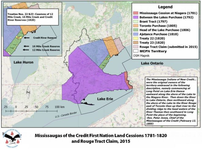
This strip of land, no higher then 10 feet above Lake Ontario waters and approximately one quarter mile wide, was first seen by our Indigenous people. All of this territory stretching the Niagara peninsula and the greater GTA is mutually covered by the ‘Dish With One Spoon Wampum Belt Covenant’, an agreement between the Iroquois and Ojibway and other tribes. This land is part of the Joseph Brant land grant 1797 (Haldimand Proclamation 1784) and the Treaty Lands of the Toronto Purchase of 1805, between the Lakes Purchase 1792 and other treaties (Treaty 3a and others) made after the American Revolution of 1776 and the early 1800s between the British and the Indigenous peoples (the Mohawks and the Mississaugas of the Credit, whose warriors helped the British in the early Revolutionary US wars and border scrimmages ) and who lived and moved along the shores of Lake Ontario. The city of Burlington with a neighbourhood known as: Tyandaga (named after Thayendanegea Mohawk Chief Joseph Brant 1743-1807) is rich in history from the Anishinaabeg to the Haudenosaunee, – lands spanning from Lake Ontario to the Niagara Escarpment.
This strip of land was first seen by a white man in 1615 when explorer Etienne Brule passed by and later in 1669 by Rene-Robert Cavelier de la Salle who went on to explore the Ohio and Mississippi Rivers and later with a Dutch/Belgian priest named Father Hennepin. The strip was formed overtime by water flowing off the escarpment from the cite of what is now the town of Dundas with waves building up a sandbar at Windermere basin and also from the north forming a gap slightly north of the present canal. In 1794 Lieutenant Governor Sir John Graves Simcoe had a building erected at the southern end of the beach called King’s Head but it was destroyed by the Americans in the war of 1812-13. Joseph Brant, the Mohawk chief (he travelled twice to England) built a house in 1802 and lived with his wife Catherine at the north end (near the today’s Joseph Brant hospital site – see the Joseph Brant Museum) having been granted 3,450 acres taking in much of what later was called the village of Wellington Square (Burlington). The Brant house had several owners over the years and in 1900 Mr. A.B. Coleman erected a hotel/Country Club on the property big enough for 300 guests. Rates were as low as $1.50 to $3.00 a room and a dinner special was $1.00 or 65 cents in the Annex. It was quite an attraction with gardens and a country club house. In 1917 the hotel portion was expropriated by the federal government at Mr. Coleman’s distress and used as a military hospital till 1923. Overtime it deteriorated and in 1937 was demolished after vandals set fire to some of the rooms. The Country Club became the Brant Inn and was a popular night spot. The older ones among us will remember the Brant Inn for music bands and dancing in the 1940s, 50s and 60s. Because Toronto Niagara traffic flowed through this area the Hon. T.B. McQuesten who was Ontario Minister of Highways in the 1930s considered a tunnel under the canal to ease the flow of traffic across the lift bridge. This never materialized (too bad!) and the Queen Elizabeth Way was opened in 1939 meeting up with Highway #2 at the Burlington Lakeshore Road side. The present canal was built in 1823 and a wooden lighthouse was installed in 1838 with Mr. George Thompson as lighthouse keeper. Sparks from a steamer, the ‘Ranger’, burned down that lighthouse and the keepers house so a new lighthouse was built of stone in 1858.
Further along moving from Burlington’s Spencer Smith Park, we cross the canal via the Lift bridge installed in 1962 and we can view the Hamilton’s industrial lands (Stelco and Dofasco steel makers) Already back to 1826, there have been 5 different moveable bridges located at this site. (bridges were installed for Highway 2 traffic and Hamilton and the North-West Railroad – H&NW railroad crossings) A new through-truss swing-bridge swung by hand was installed for the railway in 1877. A newer electric bridge came later in 1903. In 1952, a Lake boat met the immovable object and destroyed the still lowered roadway bridge. “We didn’t have radio contact back then, and when we went to raise one side of the bridge she didn’t move. Well, we got the other side up, and we thought the boat would swing over and go through the other lane. Well, she didn’t.” The Lake boat, dragged its anchor and blew its whistle furiously, but crumpled the bridge and created huge traffic jams. Thoughts then turned to make plans for a Skyway Bridge high enough for ships to go under. It was opened in 1959 for the QEW expressway (Toronto-Niagara Falls) stretching from Lakeshore Road in Burlington to Woodward Ave past along Eastport drive and Windermere Basin Park and also connecting with the Red Hill Valley Parkway.
An amusement park had operated just south of the bridge till 1978. (I remember taking our kids there with my dad in the 70s) The Royal Hamilton Yacht Club (1891) and several hotels were constructed on the beach at the end of the 1800s. Some of all this lasted into the 1950s with the renown Burlington Brant Inn closing in 1969.
The railway was removed in 1982, and the road then widened to four lanes. The present bridge is a tower drive type, vertical lift movable bridge owned and managed by the Federal Government. The lift span is 116 meters long, 19.8 meters wide, weighs 1995.8 tons, and has a vertical lift of 33.5 meters. A system of machinery, sheaves and wire ropes originating at the towers is used to move the lift span. There is one 150 hp drive motor in each of the two towers to power the machinery and one 150 hp synchro-tie motor in each tower to synchronize the drive motors at each end of the span. The bridge is an important link between the cities of Hamilton and Burlington and is a vehicular alternate to the Burlington Skyway. It operates for ships from roughly mid-March to the end of December each year and provides shipping access between Hamilton Harbour and Lake Ontario.
When the railway was abandoned, the railway bridge was demolished. The Beach Trail was begun and as we cross the bridge we are now in the city of Hamilton. Many fine houses and cottages were built to accommodate guests and summer activities along Van Wagners Beach Road from the late 1800s to the present day. Many people walk to the bridge from the Burlington side to view ship and boat traffic flowing through the canal. The regular tall old light house by the bridge has been vacant for sometime and is waiting to be moved to a better viewable location. The Lake entrance to the canal also has a smaller light house fully equipped with up-to-date electronic gear for monitoring lake traffic, especially as the bridge keeper needs sufficient warning to get it lifted for Lake steamer traffic. Watching the large Lake steamers and leisure boats passing by with the bridge being raised and lowered is a wonderful experience. On the Burlington northside of the bridge facing the Hamilton Bay we see the Canada Centre for Inland Waters building. (600 staff from Environment Canada (EC), the Department of Fisheries and Oceans, the Canadian Coast Guard, and the Royal Canadian Mounted Police) There is opportunity to store and launch boats by the bridge Bayside also.
All other activities along the entire beach going south on the Water Front Trail have been fairly consistent over the years, there are some commercial establishments on the Lake side but no entertainment or other hyper retail facilities are allowed. It is basically a residential area (Beach Blvd and Van Wagners Beach Road) with lots of beach front. Some new buildings (townhouses and renewal and renovations of private residences) has been erected in the last 20 years or so which have added to the leisure outdoor escape feeling of the area. The Burlington side used to have numerous cottages facing the Beach but in the last 20 years the City of Burlington has prohibited change of ownerships so that eventually all of the strip will become public access. The only structure that is permanent is the Burlington Skyway Wastewater Treatment Plant on the opposite side of the road.
As we cross the canal, we can follow the road which will run under the Skyway bridge and continues south along the Hamilton Bay side (Eastport Drive) till it meets up with Woodward Ave (before that turn into Windermere Basin Park which is a viewpoint for bird watchers in the Spring and Fall) and take a turn left at the stop-light under the QEW which meets up again with Beach Blvd and turning another right takes you along Van Wagners Beach Road next to the Waterfront Trail.
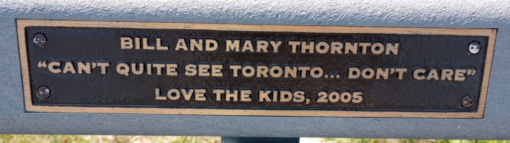
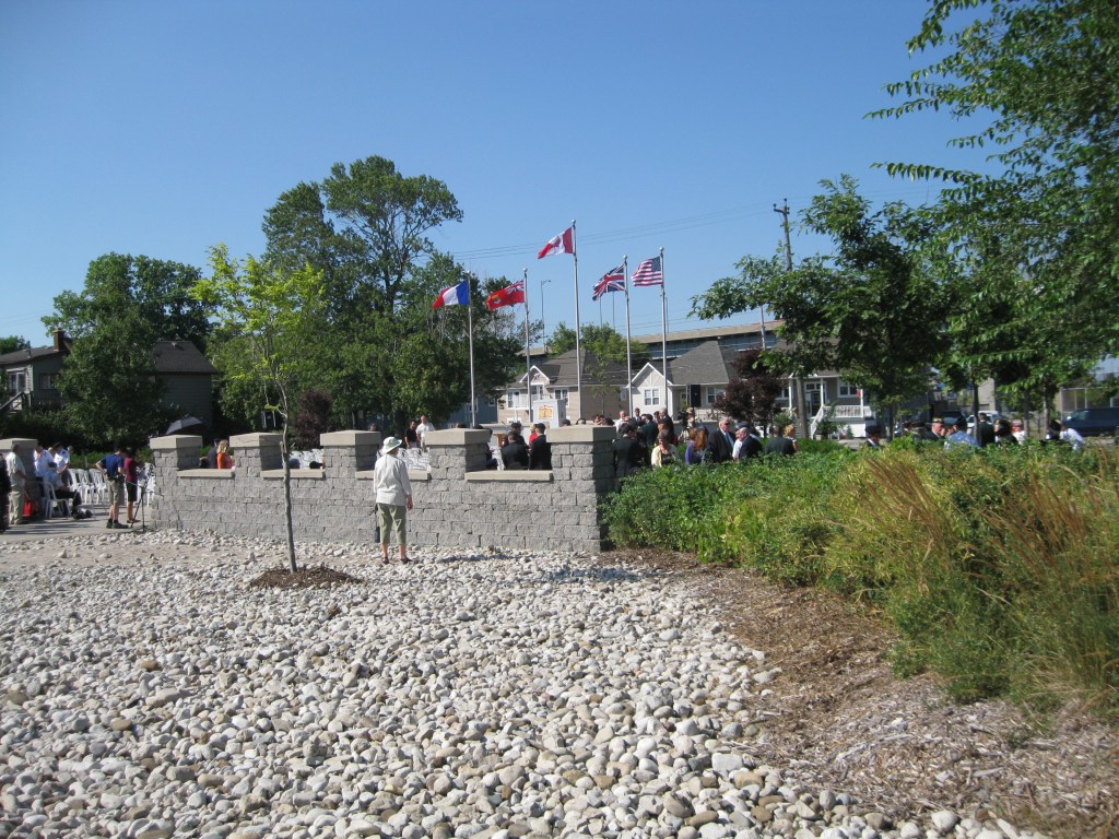
But lets go back to the Lift bridge, to start our Waterfront Trail tour. Now as we go south (there is good parking and public washroom facilities) we notice a bench with a Bill and Mary Tornton memorial plague: I love what it says. Just a few hundred feet from there is our first site, it is a monument area (Dieppe Veterans Memorial Park) dedicated to the disastrous Dieppe raid of 1942 led by mostly Canadian soldiers. (3,600 were killed and 5,000 taken prisoner). This event is remembered every August 19th with veterans and civic officials attending to remember the fallen and those that bravely fought on the shores of France, mainly to give courage to those in the free world that defeating the Nazis was possible. I have witnessed that ceremony but only a few people attend this mostly forgotten event. This location was picked, as the beach and surrounding area greatly resembled that of the French location.
As we move along the paved path we notice large and small cottages and houses backing on to the trail. Some have wonderful gardens and back yards. The trail is wide enough to have walkers, rollerbladers, skate-boarders and bikers on the trail. (bike speed is limited to 15km) We also notice a plastic walkway to the water has been installed to accommodate people in wheelchairs so they too can easily roll-up to the beach from the trail.
There are many fine cottages and houses to view of all different types. All fronting onto Beach Boulevard from which there are a few Avenues that will get you to the Waterfront Trail. At 5KM point, we notice the buildings of the Bell Cairn School site (1937) now a training facility for the Ontario Ministry of Prisons (Redeemer Christian University occupied this site for a while in the 1980s) Going on from there we pass by a Waymark statue (placed by the Hamilton Harbour Commission in 2003) of children pretending throwing skipping stones on the water. (here we can access Van Wagners Beach Road) Further along we notice the go-cart track still actively used in summer.

Near the 6KM mark is a relatively new building with a small tower outlook and a swimming pool and washroom facilities. (former Lakeland pool) Many a wedding party are seen here as it can accommodate photos opportunities. Also if you look towards the QEW, away from he Lake you will see the water intake pump building for the City of Hamilton Woodward Avenue Water Treatment Facility as it sits at the end of the Red Hill Valley Parkway merging into the QEW. On the Lake side you can see the off-shore intake structure for the Water Works facilities.
Then further a new marker was erected in 2023 that celebrates Hamilton Electric City project (Nikolas Tesla). Hamilton was one of the first cities in Ontario to use Niagara Falls produced electricity to power the lights for the city residents and streets with a power station located at the end Victoria avenue.
At the 6KM (Hamilton Beach) mark we also find the Hutch’s snack-bar/restaurant, always a family favorite; serving up ice cream, fish and chips, hot dogs, burgers and milkshakes since 1946. This is where we as teenagers in the 1950s used to travel on the Hamilton city bus to go swimming, usually not till August, as Lake Ontario waters had warmed sufficiently for us to dare a swim. Here people will gather to make full use of the beach front and is a popular gathering place for Hamiltonians.
Next we pass the ‘Barangas on the Beach’ opened since 1992, acclaimed the ‘Best Waterfront’ patio and Greek restaurant. This is a lovely gathering place for a Lakeside lunch or dinner occasions, always full when the weather is nice. For those sporty enough there is also an opportunity to play beach volley ball at the side of the building. ‘Barangas’ is only open for the summer season.


We have now reached a part called: Confederation Park. Further on, you will see a side trail to your right that crosses the Van Wagner’s road and continues along its right side pass the mini golf (Adventure Village) on the left side and then (before the roads turns to the left) take a sharp right turn that leads you over the QEW foot bridge (East Hamilton Waterfront Link Multi-Use Pedestrian Bridge 2011 – 220 meters long, spanning 12 lanes of QEW traffic) with it sort of hanging tapered unique look, and following it across to the now called Red Hill Valley Trail will get you into East Hamilton streets (Brampton Street) by the Hamilton Public works site and Water facilities. Then if you are brave enough, stay left on the trail that leads besides the Red Hill Valley Parkway and go all the way up the escarpment to come out near Albion Falls and beyond. You could even turn west at this point and follow the Rail Trail to downtown Hamilton, Corktown district (Wellington & Forest Ave)
Going back across the QEW to the Water Front Trail resuming your journey and before you reach the large Wild Waterworks parking lot, turn right and cross a small bridge for a unique visit with an occurrence that took place in the early 1800s. There you will find the ‘War of 1812 Naval Memorial Garden’ remembering fifty-three sailors who lost their lives when their ships, HAMILTON and SCOURGE capsized during a storm in the early morning hours of Sunday, 8th August 1813. The site has rows of markers with the sailors names and their ship positions listed. Another Canadian history lesson.
Getting back to the Waterfront Trail you will see recreational spaces as you approach the Wild Waterworks Park (at 7KM) with its water slides and wave pool. One of the slides is called, as I remember, the ‘Kamikaze’ where I hurt my neck on the way down and realized that is why they called it such, as it surely is fit only for those who ‘dare take excessive risks’! Outside by the Wild Water Park is a huge parking lot with picnic tables, snack bar and washroom facilities. This is a great place for family picnics and I have seen many parents bring their kids and friends here to enjoy the open spaces and have a family dinner or BBQ and take to the beach for a swim. Access to the parking lot and picnic/beach area is FREE!
Next as you pass by the ‘Wild Waterworks’ you can get a glimpse of the pool and the water slides. The Waterworks is a great place to take the kids on a hot summer day it is only open during the summer months and is always well attended.
As we are now past the Wild Waterworks park, we notice a large pond which is fed with water flowing from the escarpment down along the Red Hill Valley to its Lake outlet. Here is an opportunity to sit and watch the swans and other water fowl. Maybe even observe a grey heron standing silently along the beach water waiting for its next meal. We are now near the end of our beach front journey.

As we cross the small foot bridge across the stream, we notice a wide open space on our right side, this is Confederation Beach Park Playground, formerly a camping and trailer facility, now turned into a Cricket pitch, pickle ball courts with new facilities installed, including playground equipment (with Zip line), batting cage and public washroom facilities with accommodation for parking coming through an entrance off the North Service road. Before we turn and take the route around the park we see the end of our Waterfront Trail at Grays road, already we are in Stoney Creek. We have travelled approximately 8KM from the Lift Bridge and canal that divided Burlington and Hamilton.
Of course all along the trail there is opportunity to swim as the beach is (Free) open along the entire route. There are always more sights to explore and I have just listed some of them with a small slice of history. As we now head back to our starting point at the Lift bridge we will have completed a distance 16KM. A great ride for an afternoon!

I believe this area of Hamilton is getting more popular but still underrated and people will drive many miles to enjoy beach activities while we have this treasure right outside our Burlington/Hamilton homes. Get out there and enjoy it.
It’s a GEM!
Looking forward to summer 2025!
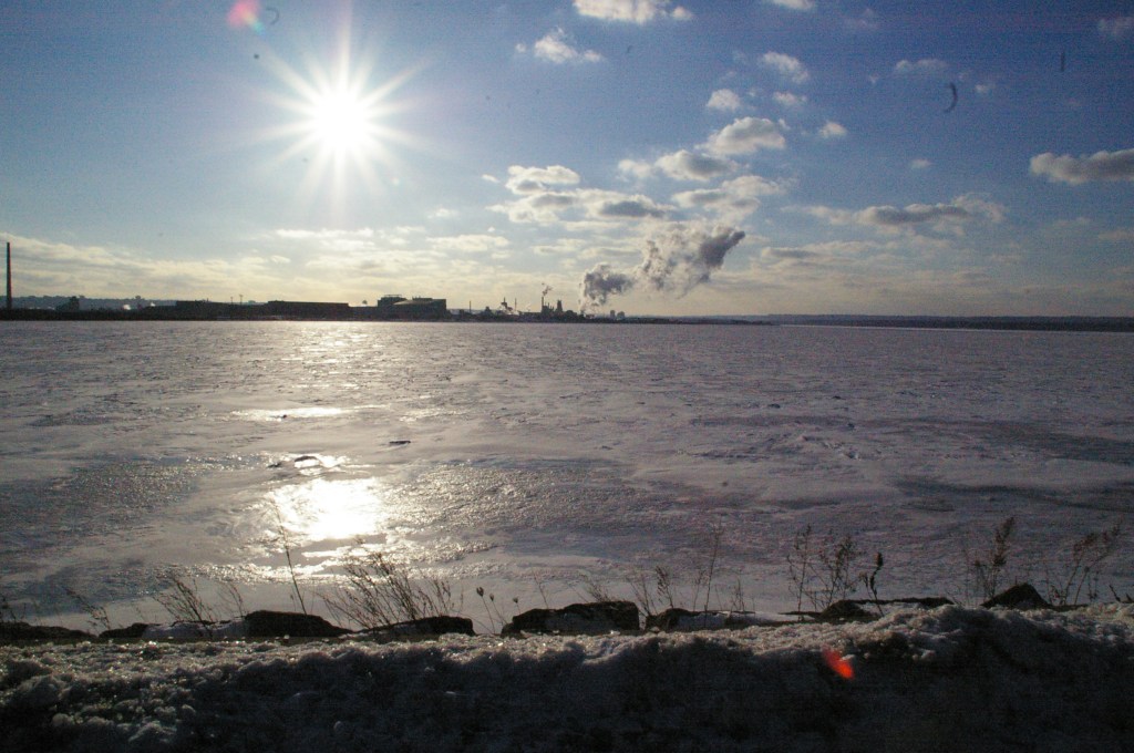
Pictures below: left to right starting at top – 1. before the storm; map Water Front Trail; beach – 2. biking around the Bay 2022; Lift bridge & QEW overpass; beach in winter – 3. Burlington side winter beach; harvest moon rising; Lighthouse – 4. Dieppe ceremony; trail; ship under Liftbridge.


JS July 1, 2025
